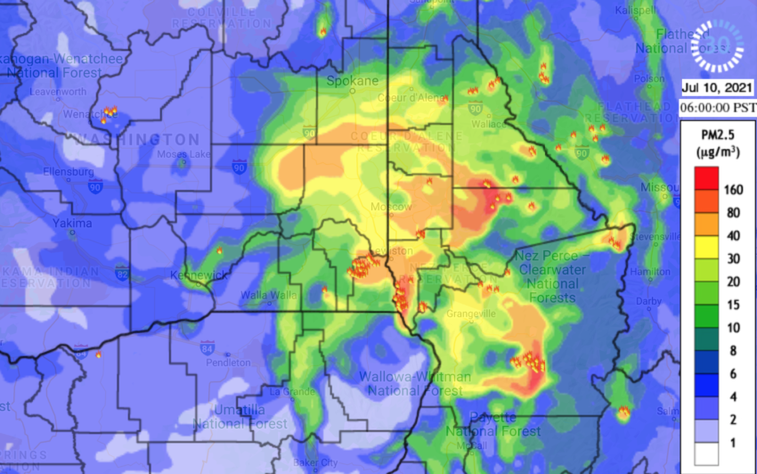
As wildfires and the resulting smoke strike the Inland Northwest again this summer here are a number of online resources for finding reliable fire information as well as checking forecasts on smoke and air quality impacts throughout the region.
TRACKING WILDFIRES
The InciWeb interactive map provides updated information on many of the larger active wildfires in the U.S. This link shows active fires in Washington state or view the embedded map at the bottom of this page.
Clicking on fire icons will bring up details on the fire events and the latest updates available on size, containment or evacuation zones. You can also find links to other national fire centers, maps or state information.
The National Wildfire Coordinating Group also has a map of regional fire events with different information on fire detections and jurisdictions.
The Southeast Washington Interagency Incident Management Team has also been active in posting updates on regional wildfire events this season with many links to relevant social media accounts.
The state Department of Natural Resources offers a detailed wildfire information page on resources, maps and contacts. You can also follow their Twitter updates here: @waDNR_fire
The Northwest Interagency Coordination Center runs a blog of updates on active fires with details on status, containment and other factors.
Whitman County Emergency Management also has an emergency notification listing you can register with to receive updates on any critical incidents in your area.
Pullman Radio News and KLEW also provide regular news reports on active fire events in Whitman County.
SMOKE FORECASTS & AIR QUALITY
Washington Smoke serves as a clearinghouse of information from state, federal and tribal agencies regarding active fires, smoke conditions and health effects. The website includes a blog on the latest updates, forecasting for upcoming air quality and a number of fire response links.
WSU offers one of the more sophisticated air quality forecasting tools with its AIRPACT website. The daily smoke forecast page offers an hour-by-hour prediction of conditions for the current and following day. The map also notes the location of prominent, active wildfires to help illustrate smoke distribution.
Update, July 12: WSU Environmental Health also provides information on wildfire smoke here as well as air quality tracking based on readings from Martin Stadium.
The state Department of Ecology also provides an air quality forecast for the next five days here.
AirNow provides regular Air Quality Index readings as well as general forecasts for the next four days. AQI measurements above 100 are considered unhealthy for sensitive groups. Measurements above 150 become unhealthy for the general public and outdoor activities are discouraged. Read more on health ratings here.
Your smartphone weather app may include air quality readings from Breezometer, which provides regularly updated Air Quality Index measurements. Different air quality measurements may come from different sources or receive updates at different intervals, leading to different readings or predictions.
The National Weather Service station in Spokane also provides timely updates on Red Flag Warnings and other relevant regional conditions via its Facebook page and Twitter posts.
If you have other resources to recommend, please send them to us at: whitmancowatch@gmail.com

Jacob, you have included an amazing number of resources in this post and I hope it is widely shared. Thanks for an outstanding contribution to local public health.
Thanks for sharing these links, Jacob! They’re super helpful. I’ll confirm with the ARC Information and Planning team that they are aware of these resources.